Blog Archives
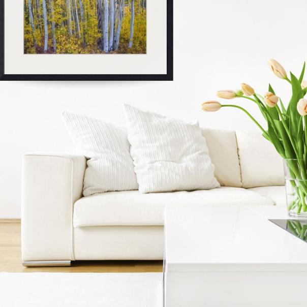
Golden Wilderness Art Print

Beautiful aspen tree golden leaf forest in the colorful autumn season of the Colorado Rocky Mountains. This was taken in the Kebler Pass area, Gunnison County. Nature’s fall foliage at it’s best. Another season gone by. Leaves are mostly gone now and winter is on it’s way. I love it all.
Order Prints, Framed Prints and Canvas Prints on ImageKind HERE
Stock Photography Images and Licensing HERE

Check out this COOL Golden Wilderness Shower Curtain
“Golden Wilderness” shower curtain by James BO Insogna. 100% polyester fabric. 71″ wide x 74″ tall. Ships within 2 – 3 business days.
About Shower Curtains
Our shower curtains are made from 100% polyester fabric and include 12 holes at the top of the curtain for simple hanging from your own shower curtain rings. The total dimensions of each shower curtain are 71″ wide x 74″ tall.
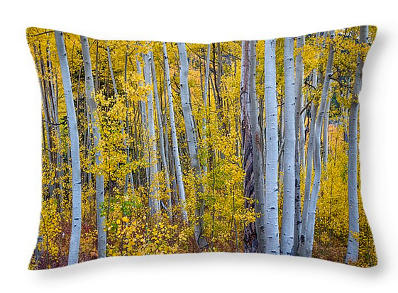
Love these Golden Wilderness Throw Pillow 20″ x 14″ too!
“Golden Wilderness” throw pillow by James BO Insogna. 100% cotton. Available in multiple sizes. Ships within 2 – 3 business days.
About Throw Pillows
Our throw pillows are made from 100% cotton fabric and add a stylish statement to any room. Pillows are available in sizes from 14″ x 14″ up to 26″ x 26″. Each pillow is printed on both sides (same image) and includes a concealed zipper and removable insert (if selected) for easy cleaning.
Colorado nature autumn landscape photography fine art prints and stock images for licensing by James Bo Insogna (C) – All Rights Reserved.
Golden Forest Portrait

Nature’s fall foliage at it’s best, beautiful aspen tree golden leaf forest portrait in the colorful autumn season of the Colorado Rocky Mountains. This was taken in the Independence Pass area.
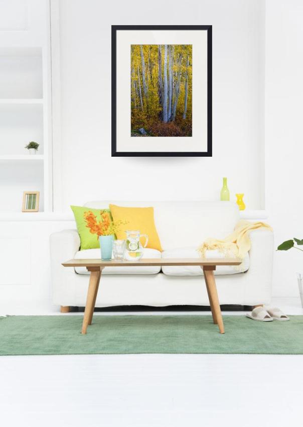
This timeless fine art photography aspen tree print will enhance and set a mood in your home or office décor plus add a sense of tranquility, peace and nature beauty to your walls.
Order Prints, Framed Prints and Canvas Prints on ImageKind HERE
Stock Photography Images and Licensing HERE
Colorado nature autumn landscape photography fine art prints and stock images for licensing by James Bo Insogna (C) – All Rights Reserved.
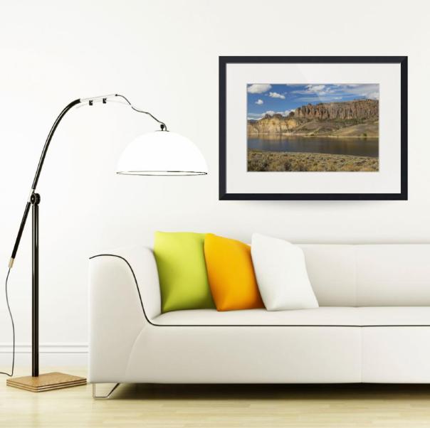
Blue Mesa Dillon Pinnacles

A scenic landscape view across the Blue Mesa Reservoir to the Dillion Pinnacles, Gunnison County, Colorado. Geologist believe the the story began about 65 million years ago when the surrounding landscape was slowly uplifted to form the Gunnison uplift and the Sawatch Range.
The origin of the pinnacles began about 30-35 million years ago during a period of considerable volcanic activity. Repeated eruptions built up mountainous piles of debris to form West Elk Mountain and San Juan Mountains to the south. Lava, mud flows and rocks from exploding volcanic cones began to for the breccia that makes up the Dillion Pinnacles,
Order Prints, Framed Prints and Canvas Prints on ImageKind HERE
Colorado nature landscape photography fine art prints and stock images by James Bo Insogna (C) – All Rights Reserved.

Colorful Forest

Autumn view in Cottonwood Pass (elevation 12,126 feet is a high mountain pass in the Rocky Mountains of south-central Colorado, United States. It is located near the border of Gunnison and Chaffee counties in Colorado and is in the Sawatch Range. The area surrounding the pass is mostly forest, with the San Isabel National Forest to the east and the Gunnison National Forest to the west. Read the rest of this entry

Colorful Autumn Forest In The Canyon of Cottonwood Pass

Colorful autumn forest in the canyon of Cottonwood Pass. Cottonwood Pass (elevation 12,126 feet is a high mountain pass in the Rocky Mountains of south-central Colorado, United States. It is located near the border of Gunnison and Chaffee counties in Colorado and is in the Sawatch Range. The area surrounding the pass is mostly forest, with the San Isabel National Forest to the east and the Gunnison National Forest to the west. Read the rest of this entry

City of Crested Butte Colorado Panorama

Crested Butte is located in Southwest Colorado, 28 miles north of the City of Gunnison. Crested Butte is the eighth largest historic district in the state of Colorado. Elevation: 8,885 ft . Crested Butte is a Home Rule Municipality in Gunnison County, Colorado, USA. A former coal mining town now called “the last great Colorado ski town,” Crested Butte is a destination for skiing, mountain biking, and a variety of other outdoor activities. The population was 1,487 at the 2010 census. Read the rest of this entry
Aspen Tree Magic Cottonwood Pass

Portrait view of colorful aspen trees in the Cottonwood Pass Area. Cottonwood Pass (elevation 12,126 feet is a high mountain pass in the Rocky Mountains of south-central Colorado, United States. It is located near the border of Gunnison and Chaffee counties in Colorado and is in the Sawatch Range. The area surrounding the pass is mostly forest, with the San Isabel National Forest to the east and the Gunnison National Forest to the west.
Read the rest of this entry
Aspen Tree Magic

Autumn aspen tree forest in the Colorado Rocky Mountains Cottonwood Pass area. Cottonwood Pass (elevation 12,126 feet is a high mountain pass in the Rocky Mountains of south-central Colorado, United States. It is located near the border of Gunnison and Chaffee counties in Colorado and is in the Sawatch Range. The area surrounding the pass is mostly forest, with the San Isabel National Forest to the east and the Gunnison National Forest to the west. Read the rest of this entry
Colorful Crested Butte Colorado

Scenic landscape view of Colorful Crested Butte Colorado area. This has to be one of my most favorite places in Colorado and a town I always thought I would end up living in.
Crested Butte is a Home Rule Municipality in Gunnison County, Colorado, United States. A former coal mining town now called “the last great Colorado ski town, Crested Butte is a destination for skiing, mountain biking, and a variety of other outdoor activities. The population was 1,487 at the 2010 census . Read the rest of this entry
Rocky Mountain Rural Rustic Cabin Autumn View

A scenic autumn landscape with a rustic rural cabin in the high country of the Colorado Rocky Mountains with colors of autumn aspen trees in the background. Near Crested Butte, Gunnison County. How would you like to wake up to this view everyday? Read the rest of this entry

