Blog Archives
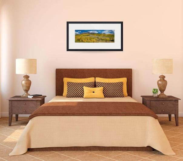
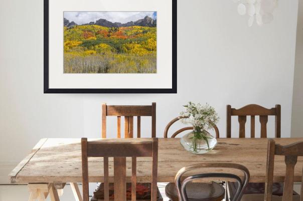
Kebler Pass Autumn Season Panorama Print

A very large panorama scenic view of Kebler Pass 10,007 ft, autumn season colors just west of Crested Butte. in Gunnison County, Colorado.
Order Prints, Framed Prints and Canvas Prints on ImageKind HERE
Stock Photography Images and Licensing HERE
Colorado nature autumn landscape photography fine art prints and stock images for licensing by James Bo Insogna (C) – All Rights Reserved.
Colorful Kebler Pass Fall Foliage Art
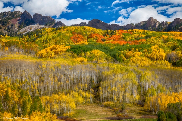
Scenic nature landscape view of the magnificent Kebler Pass, 10,007 ft, in the colorful autumn season. Kebler Pass is just west of Crested Butte. in Gunnison County, Colorado. Fall foliage at it’s best.
Bring the colors of nature and peaceful calm tranquility of the outdoors into your home or office decor with this beautiful fine art nature landscape print.
Order Prints, Framed Prints and Canvas Prints on ImageKind HERE
Colorado nature autumn landscape photography fine art prints and stock images by James Bo Insogna (C) – All Rights Reserved.
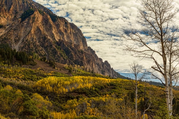
Colorado Kebler Pass Fall Foliage
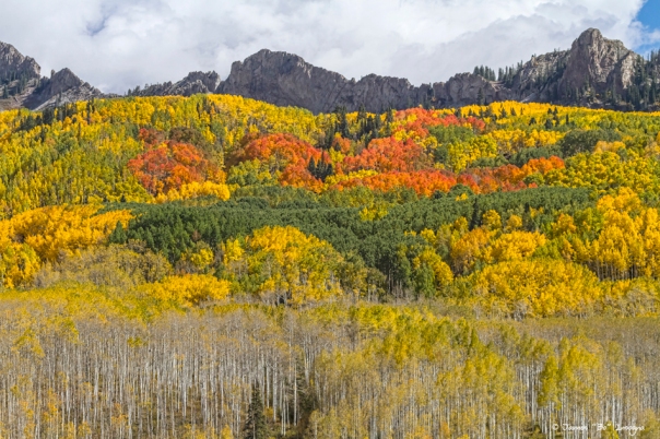
A beautiful scenic view of the incredible Kebler Pass , 10,007 ft in elevation, fall foliage, the autumn season colors at it’s best. Kebler Pass is located just west of Crested Butte in Gunnison County, Colorado. This was the only place we saw the deep reds and orange aspen trees. Fantastic place to see the Colorado fall foliage colors.
Put this place on your list as a must see for fall foliage. If you missed it or can not get to this majestic place, why not buy a print to enhance your home or office decor and enjoy this view all year long.
Order Prints, Framed Prints and Canvas Prints on ImageKind HERE
Colorado nature autumn landscape photography fine art prints and stock images by James Bo Insogna (C) – All Rights Reserved.
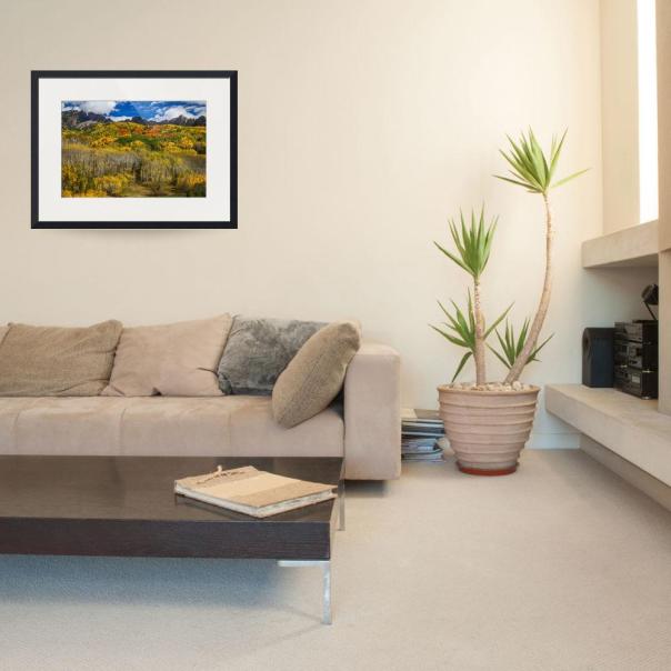
Autumn Season Rocky Mountain Kebler Pass Panorama

Scenic large panorama nature landscape view of the magnificent Kebler Pass, 10,007 ft, in the colorful autumn season. Kebler Pass is just west of Crested Butte. in Gunnison County, Colorado. Fall foliage at it’s best.
Colorado nature autumn landscape photography fine art prints and stock images by James Bo Insogna (C) – All Rights Reserved.
Colorado Rocky Mountain Autumn Season Beauty

A beautiful scenic view of Kebler Pass 10,007 ft in elevation, autumn season colors at it’s best located just west of Crested Butte in Gunnison County, Colorado.
Colorado nature autumn landscape photography fine art prints and stock images by James Bo Insogna (C) – All Rights Reserved.
Rocky Mountain Autumn Glory
A beautiful scenic view of the Kebler Pass area that is 10,007 ft in elevation, autumn season in it’s glory, nature at it’s best. Kebler Pass is located the the southwest part of the state, just west of Crested Butte in Gunnison County, Colorado.
Colorado nature autumn landscape photography fine art prints by James Bo Insogna (C) – All Rights Reserved.
Please Feel Free to share our links, with Family or Friends who may also enjoy them.
Colorado Rocky Mountain Love

Please click on the image for the iGallery
You have to love the Colorado Rocky Mountains with Lake views like this! One of my most favorite places on earth Brainard Lake, the Indian Peaks Wilderness Area, Roosevelt National Forest, Boulder County, Colorado. You are looking at the continental divide, I used to camp up here in the middle of winter and cross county ski up to the bowls. Just me and my dog Jeff. Great times to remember, but those days are gone. You never know though…. the snow shoeing is really good here too.

Put a little Rocky Mountain Love above your bed.
Order Prints, Framed Prints and Canvas Prints on ImageKind HERE
Buy Royalty Free Stock Photography Images and Licensing HERE
Colorado fine art nature landscape photography images by James Bo Insogna (C) – All Rights Reserved.
Medicine Bow Mountain Range Lake Panorama
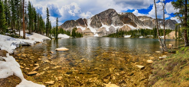
Panorama scenic lake view of the Medicine Bow Mountain Range in Wyoming west of Laramie. Two and half hour drive from Boulder County, Colorado. Great day trip. This is a very large 12 portrait images stitched together fine art panorama print.
The Medicine Bow Mountains are a mountain range in the Rocky Mountains that extend for 100-mile from northern Colorado into southern Wyoming. The northern extent of this range is the sub-range the Snowy Range. From the northern end of Colorado’s Never Summer Mountains, the Medicine Bow mountains extend north from Cameron Pass along the border between Larimer and Jackson counties in Colorado and northward into south central Wyoming. In Wyoming, the range sits west of Laramie, in Albany and Carbon counties to the route of the Union Pacific Railroad and U.S. Interstate 80.
High elevations, peaks and lakes dominate the southern and northern reaches of the range, with lower, forested ridges being the mainstay in between. On the western fringes of the central portion of the range, the North Platte River cuts a deep, narrow, canyon over 20 miles long. The range features 18 peaks over 11,000 feet and includes 9 over 12,000 feet, with 12,951 ft. Clark Peak being the highest.

- Custom order this image as Fine Art Prints, Framed Prints, Canvas Prints, Acrylic Prints, Metal Prints, Phone Cases, Throw Pillows and Duvet Covers at BoInsogna.com HERE
- Order Prints, framed Prints and Canvas Prints on Striking-Photography.net HERE
- Buy Royalty Free Stock Photography Images and Licensing HERE
Colorado fine art nature landscape photography images by James Bo Insogna (C) – All Rights Reserved.
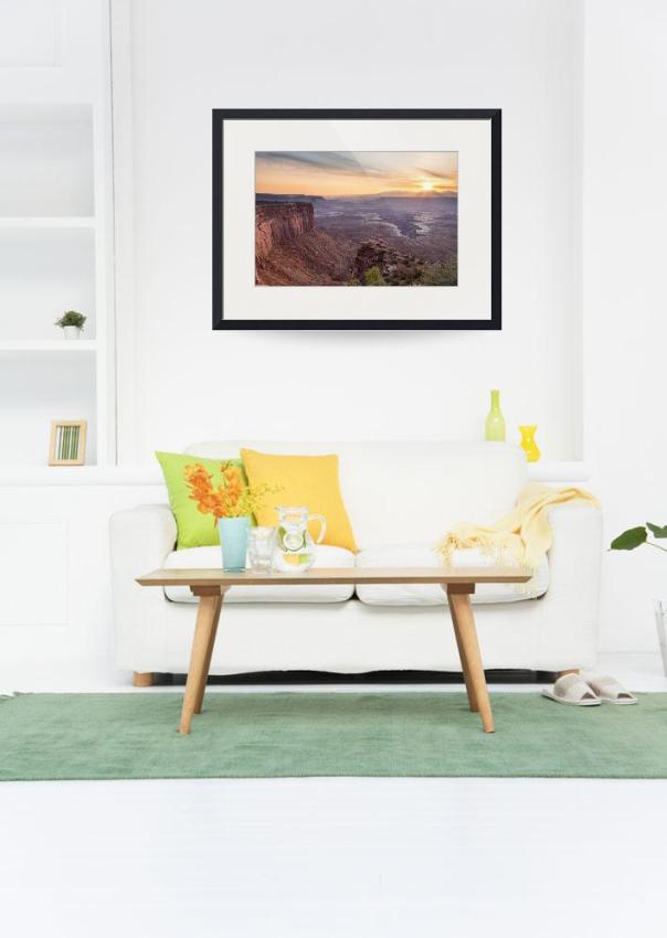
Canyonlands Utah Sunrise

This was one of the last stops on our road trip from Colorado to Arizona and back again through Utah. We ended here at night and woke up to this beautiful scenic landscape.
Canyonlands National Park is located in southeastern Utah near the town of Moab. It preserves a colorful landscape eroded into countless canyons, mesas, and buttes by the Colorado River, the Green River, and their respective tributaries. Legislation creating the park was signed into law by President Lyndon Johnson on September 12, 1964
The park is divided into four districts: the Island in the Sky, the Needles, the Maze, and the rivers themselves. While these areas share a primitive desert atmosphere, each retains its own character. Two large river canyons are carved into the Colorado Plateau by the Colorado River and Green River.
Weird fact: Nineteenth century cowboys corralled wild horses onto today’s Dead Horse Point State Park. Supposedly, one herd left on the point died of thirst.
Scientific fact: Cataract Canyon may be one of the world’s most actively filling canyons. Scientists discovered 260 feet of sediment below the water’s surface.
Buy Royalty Free Stock Photography Images and Licensing HERE
Utah fine art nature landscape photography and stock images by James Bo Insogna (C) – All Rights Reserved.
Bryce Canyon National Park Views
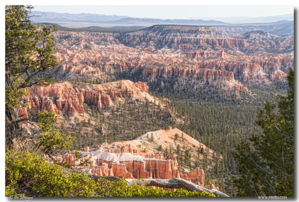
Scenic landscape view into Bryce Canyon National Park. A spectacular place to visit.
Interesting fact: Water, ice, and gravity are the natural forces that formed the geological “hoodoos” that make Bryce Canyon unique.
This park is named after Ebenezer Bryce, who started ranching the area in 1875. Upon showing the canyons to visitors, he is said to have remarked, “It’s a hell of a place to lose a cow.”
Bryce Canyon’s rocks are among the youngest of those on the Colorado Plateau, dating back a mere 65 million years ago to the Cretaceous period.
Cool fact: Most rural parts of the U.S. have 2500 stars visible on any given clear night. At Bryce Canyon, that number jumps to a whopping 7500. Currently, these essential remaining dark night skies are being threatened by mining in the nearby community of Alton. The mining will potentially adversely affect the clear skies. It is a hugely contentious situation.
Geological fact: Bryce Canyon isn’t actually a canyon. It’s actually a natural amphitheater.
Total Area 35,835 acres – Annual Visitation 1,385,352 in 2012 (view all years) – Park Creation Date September 15, 1928 – Entrance Fee $25 per vehicle per week – Time Zone Mountain – Lowest Elevation 6,620 feet at Yellow Creek – Highest Elevation 9,115 feet at Rainbow Point – Lowest Average Temp 9°F in January – Record Low Temp -26°F in 1963 – Highest Average Temp 78°F in July – Record High Temp 98°F in 2002

Buy Royalty Free Stock Photography Images and Licensing HERE
Fine art Utah nature landscape photography and stock images by James Bo Insogna (C) – All Rights Reserved.
Please Feel Free to share our links, with Family or Friends who may also enjoy them.
If you like my Art Gallery, it would be awesome if you help spread the word and press the Pinterest, FB, Google+, Twitter or SU Buttons!
Thank you!
Bo Insogna
Facebook: http://www.facebook.com/StrikingPhotographyByBo
Twitter: http://www.twitter.com/Lightning_Man
Google Plus: https://plus.google.com/+BoInsogna
Recent Striking Fine Art Photography Post, Prints and Images:
Astrophotography Night Black And White Portrait View
Bryce Canyon National Park Utah Views Video
Arches National Park Utah Castle Panorama
Forest Star Gazing An Astronomy Delight
Great Sand Dunes National Park And Preserve Panorama Art Print
Great Sand Dunes National Park April Views Video
Galaxy Night Fine Art Photography Print
Plains – Dunes And Rocky Mountains Panorama Black White Art Print
Deer On The Plains Great Colorado Sand Dunes
Morning in Great Colorado Sand Dunes vBlog
Fine Art Photography Prints available in all sizes custom to order. Fast, Safe and Secure.

